Buffalo Gap Drilling
Joint Venture
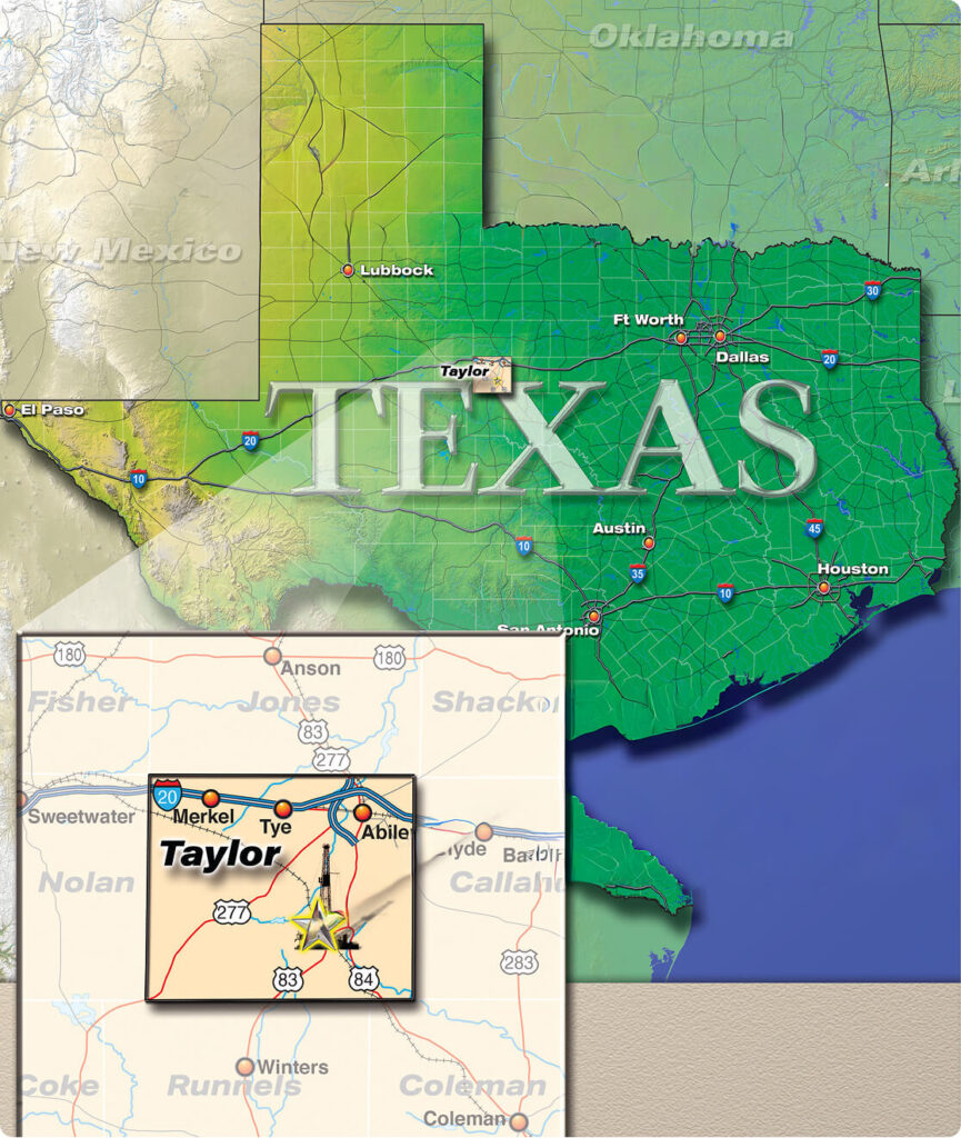
Bend Arch-Fort Worth Province Taylor County, Texas
- Project
Field Re-Development Project (Upper Gray Sand)
Bend Arch Region, Taylor County, Texas
PROJECT
Buffalo Gap Joint Venture
“Bend Arch-Fort Worth Province” of Central Texas.
Eagle Natural Resources is actively acquiring and re-developing proven, producing oil and gas properties with strong upside in one of the top historic oil and gas regions, the “Bend Arch-Fort Worth Province” of Central Texas. The USGS estimates that the Bend Arch-Fort Worth Basin Province contains approximately 98.5 million barrels of oil and 26.7 trillion cubic feet of gas of undiscovered oil and gas reserves (See Pages 14 and 15 for the USGS Study). The Buffalo Gap Drilling Joint Venture is located in Taylor County, Texas and the project will develop proven reserves via a one-well drilling program in an established oil and gas field, seeking to exploit the remaining potential of this mature, oil-rich province. Of the total estimated remaining reserve potential of the Bend Arch region, the “Pennsylvanian/Permian Fluvial-Deltaic Sandstone” petroleum system, which includes the main target “Upper Gray Sand” reservoir, accounts for 38% of the remaining potential in the province (or 35.8 million barrels oil of 98.5 total million barrels).
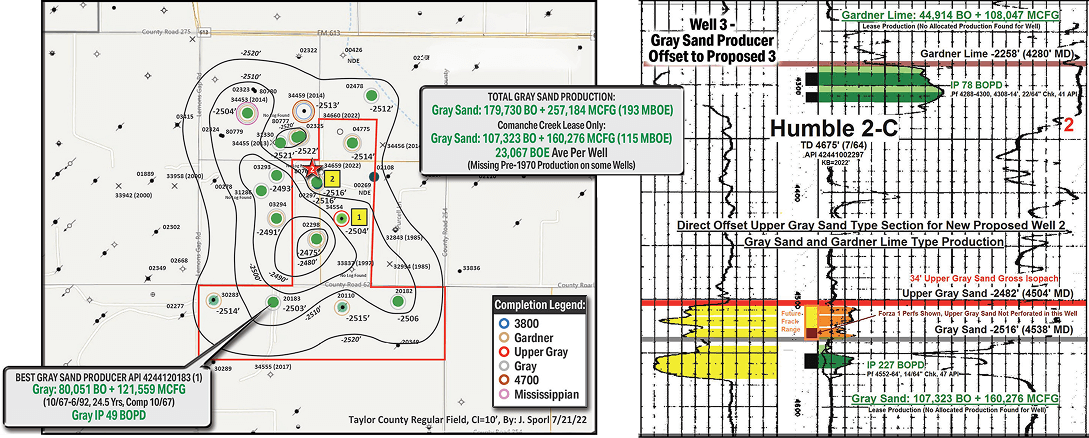
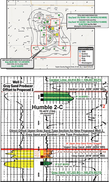
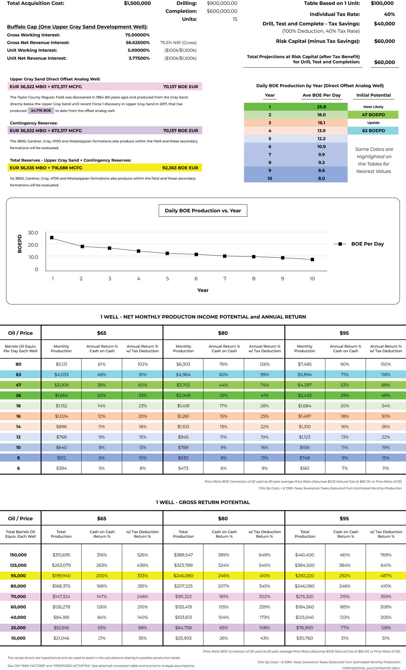
The Buffalo Gap Drilling Joint Venture is comprised of a 285-acre HBP (held-by-production) lease which is currently active with one well producing from the Upper Gray Sand. Nine additional wells were drilled and produced in the deeper Gray Sand but are all plugged and abandoned now. Cumulative production from the lease to date totals 162,948 barrels oil and 464,780 thousand cubic feet gas, or 186,187 barrels oil equivalent, from three reservoirs – the Gray Sand, Gardner Lime and Upper Gray Sand (new reservoir).
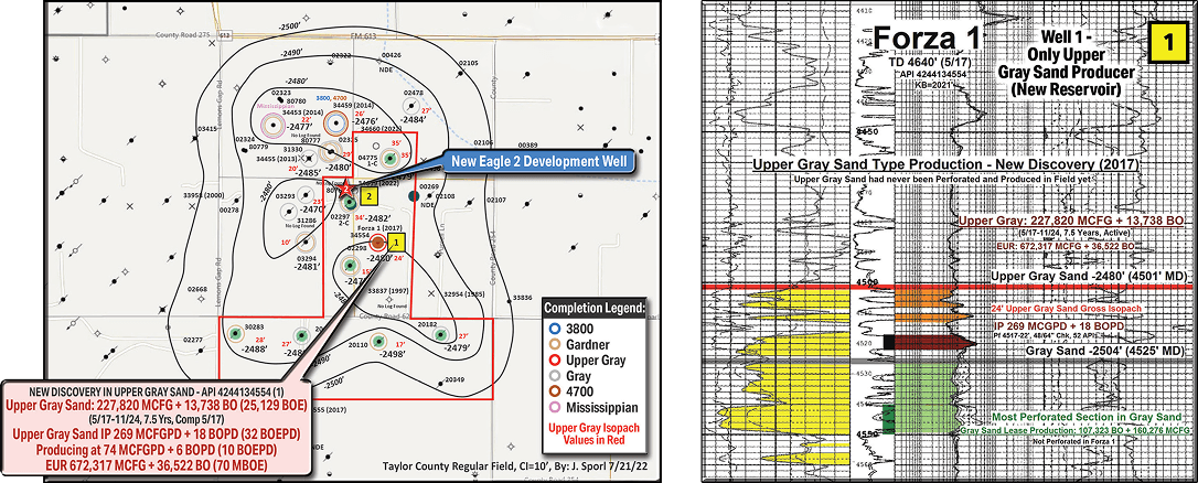
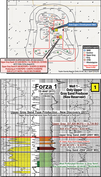
In 2017, the Forza 1 well was the first well in the field to be completed in the Upper Gray Sand with the well being hydraulically fractured (or “fracked”) immediately above the main porosity zone in the Gray Sand, which is in communication with the shallower Upper Gray Sand. Historically, operators had only perforated the lower member of the Gray Sand due to its higher porosity and permeability. However, with fracture treatment applied to the Forza 1 well, the Upper Gray Sand released unproduced natural gas and oil (attic reserves) at an initial rate of 269 thousand cubic feet gas and 18 barrels oil (or 32 barrels oil equivalent per day). The Upper Gray Sand has already produced 227,820 thousand cubic feet gas and 13,727 oil (or 25,118 barrels oil equivalent) in 7.5 years. The well is currently producing at a reduced rate of 2 barrels oil and no natural gas, as a new gas line is currently being installed. The well was producing at 75 thousand cubic feet gas per day and 6 barrels oil per day (or 10 barrels oil equivalent per day) prior to the temporary shut-in of the natural gas. The well will return to the same rate or higher once work is completed. The offset Forza 1 Upper Gray Sand well has an Estimated Ultimate Recovery of 672,317 thousand cubic feet gas and 36,522 barrels oil (or 70,137 barrels oil equivalent).
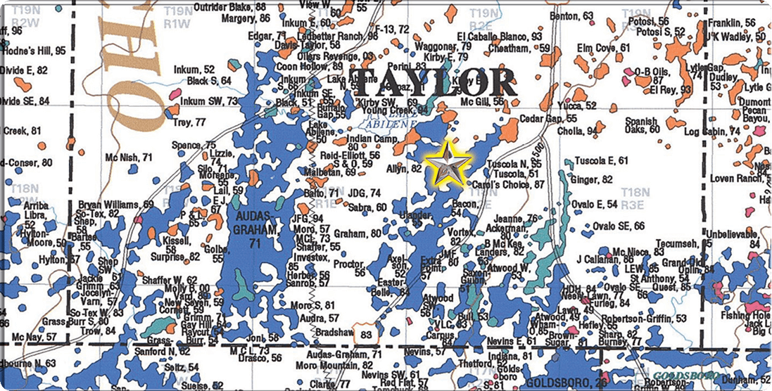
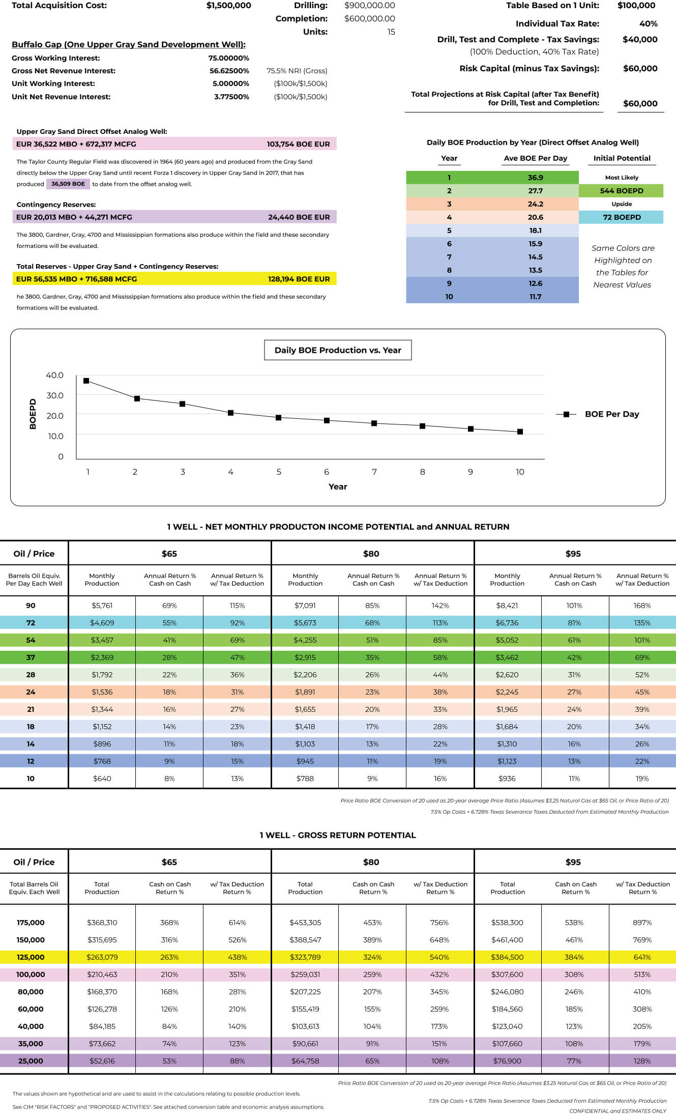
The future development plan is to drill another “rate acceleration” development well to further exploit the newly-discovered reserves in the Upper Gray Sand. One simple vertical well (shown with the red star on the maps on pages 3 and 4) will be drilled to a total depth of 5,000 feet and fracked in the Upper Gray Sand directly north of the Forza 1 well, in an area of thicker Upper Gray Sand. Log cuts are included in the presentation for the analog Forza 1 well and the Humble 2-C well directly offset to the new planned Eagle 2 location (See two key wells and log cuts annotated 1 and 2 on maps with yellow boxes, on pages 3 and 4). The Upper Gray Sand gross isopach thickness is 32 feet at the new planned location (based on the offset Humble 2-C well) which is 8 feet (or 133%) thicker than the analog Forza 1 well, which is 24 feet thick.
It should also be noted that only the lower portion of the Upper Gray Sand was fracked in the Forza 1 well, whereas the new development well will be fracking and producing the entire Upper Gray Sand. The orange-colored portion of the Upper Gray Sand shown on the Forza 1 log cut was not fracked and produced in this well, so the new development well may have higher rates and production than the Forza 1 well, since Eagle will be fracking the entire Upper Gray Sand (orange and maroon zones on Forza 1 well log). Furthermore, as a contingency plan, there are at least five other reservoirs which will be drilled and evaluated with the new well including the 3800, Gardner, Gray, 4700 and Mississippian all of which produce either on the Buffalo Gap Lease or on the adjacent lease, which could lead to future re-completion potential. Eagle plans to drill the new development well and initiate production by Summer 2025.
Maps and Logs
One New Development Well Planned in Upper Gray Sand
in Area of Thickest Upper Gray Isopach
One Simple Vertical Development Well to be Drilled in a New Field Reservoir (Only 5,000’ Total Depth)
All Wells with Gray Circles have already Produced Oil Directly Below, and in Communication with, the Shallower Upper Gray Sand which has only One Completion Fieldwide to Date (ie. Attic Reserves to Drill, Frack and Produce)
To Maximize Production, the Upper Gray Sand Gross Isopach Thickness will be 8 feet Thicker (or 133%) at the Proposed Location as the Current Active Completion in the Upper Gray Discovery Well (Forza 1)
Five Additional Contingency Reservoirs Include the 3800, Gardner, Gray, 4700 and Mississippian, all of which Produce in Wells on the HBP Lease or the Offset Lease
Buffalo Gap Lease
Bend Arch Region - Taylor County, Texas
Upper Gray Sand (New Field Reservoir) Structure Map and Production History
Map 1: Upper Gray Sand (New Reservoir, Target)
Comanche Creek Lease
Bend Arch Region - Taylor County, Texas
Grand Sand (Main Field Reservoir) Structure Map and Production History
Map 2: Gray Sand Producer (Top Reservoir in Field)
Buffalo Gap Drilling Joint Venture
Field Re-Development Project (Upper Gray Sand) – Bend Arch
Region, Taylor County, Texas
Monthly Income Conversion Table
Buffalo Gap Drilling Joint Venture
Field Re-Development Project (Upper Gray Sand) – Bend Arch
Region, Taylor County, Texas
NATURAL GAS UPSIDE CASE – ASSUMES HIGHER NATURAL GAS PRICES AS PREVIOUS TABLE
Assumes $6.50 Natural Gas at $65 Oil (rather than $3.25 Natural Gas at $65 Oil), or Price Ratio of 10 for BOE Conversion
Monthly Income Conversion Table
There are significant risks associated with oil and gas investments. Information found on this site is for general purposes only and is not a solicitation to buy or an offer to sell securities. General information on this site is not intended to be used as individual investment or tax advice. Consult your personal tax advisor concerning the current tax laws and their applicability and effect on your personal tax situation.
Eagle Natural Resources, LLC
ENR Operating, LLC RRC # 253075
5445 Legacy Dr. STE 440 Plano TX 75024
Phone: (972) 674-1024